


Esri
Esri builds the leading mapping and spatial analytics software for desktop, software as a service (SaaS), and enterprise applications.
Definition
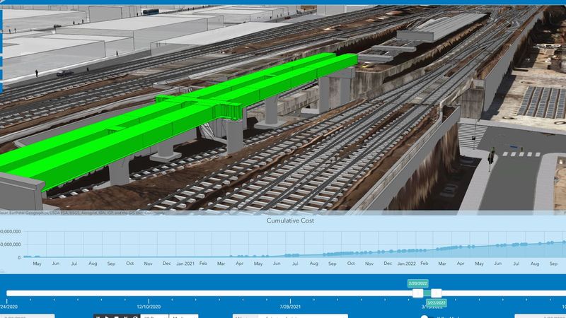
Architects, engineers, builders, and owners use Esri solutions to improve workflows, bring context to projects, and increase collaboration throughout project life cycles. GIS is helping architecture, engineering, and construction (AEC) firms build smart communities and assets for the future. Discover efficiencies, gain insights, and strengthen engagement with mapping applications across project teams. Add location to design to understand projects in context and deliver repeatable solutions. Location intelligence transforms the way we plan, design, build, and operate in the built and natural environment.
In Depth
Esri provides GIS (Geographic Information System) technology used in AEC for site analysis, infrastructure planning, and environmental assessment. AI enhances GIS analysis by automating feature extraction from aerial imagery, predictive spatial modeling, and site suitability analysis.
Tool Details
Nomic Use Cases
See how Nomic applies this in production AEC workflows:
Frequently Asked Questions
Architects, engineers, builders, and owners use Esri solutions to improve workflows, bring context to projects, and increase collaboration throughout project life cycles. GIS is helping architecture, engineering, and construction (AEC) firms build smart communities and assets for the future. Discover efficiencies, gain insights, and strengthen engagement with mapping applications across project teams. Add location to design to understand projects in context and deliver repeatable solutions. Location intelligence transforms the way we plan, design, build, and operate in the built and natural environment.
GIS is helping architecture, engineering, and construction (AEC) firms build smart communities and assets for the future.
Project Research: Instantly access all project-critical information from a single search interface.