


VU.City
To help people create, refine, share & understand the journey of development to make better planning decisions, faster
Definition
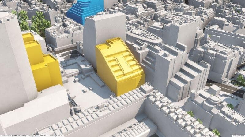
VU.CITY addresses the fundamental questions: if we build here; what will it look like; who will it affect; and how will it affect them?VU.CITY provides clarity for the built environment. Combining the power of data with the largest, most accurate 3D digital city models, VU.CITY helps us to understand the implications of change in the built environment. VU.CITY is currently live in of London, Manchester, Birmingham, Brighton and Belfast, with many more to come.By visualising proposed buildings in context, we speed up the planning process substantially. Decisions in relation to height, bulk, townscape, heritage and views can therefore be taken around the table, engaging with the design team, the client, consultants and local authority in real time.The data overlays ranging from listed buildings, transport access (PTAL), distances and duration of travel, pollution, pricing, opportunity areas and local frameworks are immediately available and visible within the 3 dimensional environment.Sp
In Depth
VU.City provides 3D city models for urban planning and development analysis. AI evaluates proposed developments against planning regulations, daylight requirements, and visual impact criteria within the city model context.
Tool Details
Examples
CITY helps us to understand the implications of change in the built environment
Frequently Asked Questions
VU.CITY addresses the fundamental questions: if we build here; what will it look like; who will it affect; and how will it affect them?VU.CITY provides clarity for the built environment. Combining the power of data with the largest, most accurate 3D digital city models, VU.CITY helps us to understand the implications of change in the built environment. VU.CITY is currently live in of London, Manchester, Birmingham, Brighton and Belfast, with many more to come.By visualising proposed buildings in context, we speed up the planning process substantially. Decisions in relation to height, bulk, townscape, heritage and views can therefore be taken around the table, engaging with the design team, the client, consultants and local authority in real time.The data overlays ranging from listed buildings, transport access (PTAL), distances and duration of travel, pollution, pricing, opportunity areas and local frameworks are immediately available and visible within the 3 dimensional environment.Sp
CITY helps us to understand the implications of change in the built environment.